|
 |
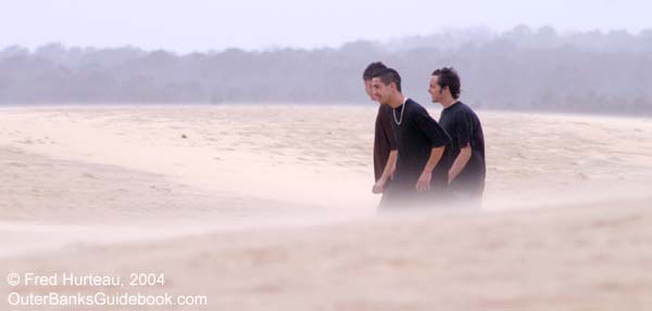
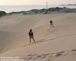
(The
scale of this photo is not obvious
until you realize the specks on the ridge are people,
better seen in this close-up.) |
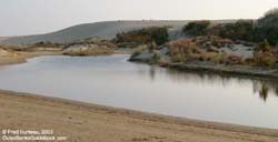
You
can't miss Jockey's Ridge if you get near Nag's Head unless
it's pitch dark. It begins just inland from the beach
on the east side, and tumbles into the sound on the west
side. The highway (NC 12) goes around it by necessity,
and barely has room to do that.
What a strange sight this is, an
ancient
mountain of sand in a place where everything around
it exists just a foot or two above mean sea level. This
tremendous dune, or actually a series of dunes, seems
to defy explanation or reason. Where did it come from?
How did it get here? Caught between the ocean and the
sound, there seems to be nowhere for it to go, and nowhere
it could have come from. Why is it here?
 |
|
North
is at the top in this aerial composite of Jockey's
Ridge assembled from NOAA
photos taken right after Hurricane Isabel.
|
|
Jockey's Ridge is certainly not
the only large dune on the Outer Banks. There are others,
mostly between Nag's Head and Carova, with Kill Devil
Hills being another well known site for large dunes or
"hills" as they were called in the early days. Old maps
and charts list places like Whales Head Hill, Poyner's
Hill, Paul Samiel's Hill, Wreck Hill and many more. But
these places were not really hills, just a fanciful use
of the term "hill" applied to larger-than-average
sand dunes. Still, on the flat, often treeless and desolate
landscape that characterized much of the Outer Banks just
a hundred years ago, these "hills" were distinctive
landmarks where nothing else could serve as such.
Jockey's Ridge was most likely the
largest of these "hills", even two and three hundred years
ago, and is today the largest
sand dune on the east coast. In fact, it is large
enough to be visible
from space, and astronauts have taken photos of it,
as in the example at right from NASA. But it is in a constant
state of flux, changing shape and size with every breeze,
and with every storm. Yet, in a chaotic way, it remains
essentially the same, and has done so for at least several
hundred years. Universities, and scientists, and scholars
have studied it, and student theses have been written
about it. Core samples have been taken to determine how
long it has been here, and to find out what might be under
it. And if you could interpret all their mumbo-jumbo techno-jargon,
you would find out that essentially what they know is
this - it's been here a long time and it's made of sand.
The rest is a lot of unanswered questions and speculation.
 |
|
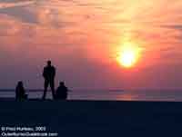
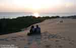
| Sunset
over Roanoke Sound viewed from Jockey's Ridge. |
|
The
wonderful thing about Jockey's Ridge is that we don't
have to worry about all that. Leave the why's and wherefore's
to the scholars All we need do is marvel at it, and enjoy
the view.
 This place is especially for children
and lovers. The kids are wild about this gigantic sandbox.
They can run and play, and really have a ball, and maybe
wear themselves out (so they'll sleep in the car, or take
a nap when you get back to your vacation lodging). Bring
a large piece of an old cardboard
box and they can use it for a sled.
This place is especially for children
and lovers. The kids are wild about this gigantic sandbox.
They can run and play, and really have a ball, and maybe
wear themselves out (so they'll sleep in the car, or take
a nap when you get back to your vacation lodging). Bring
a large piece of an old cardboard
box and they can use it for a sled.  Or
they can play
super hero, jumping down the sides in the steeper
places. They won't actually go very far, but it will feel
that way to them. They'll never forget the experience.
But it's the view and the sunsets that attract the lovers,
and the young at heart too. The park is open until at
least sunset, and it's a
great way to end a day of sightseeing. Or
they can play
super hero, jumping down the sides in the steeper
places. They won't actually go very far, but it will feel
that way to them. They'll never forget the experience.
But it's the view and the sunsets that attract the lovers,
and the young at heart too. The park is open until at
least sunset, and it's a
great way to end a day of sightseeing.
|
|
 |
 |
|
|
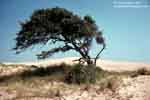 |
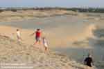
3
photos above: Both the kids and the young
at heart enjoy Jockey's Ridge.
Left:
This old tree from 1973 was gone in 2003.
The tiny specks atop the dune in the background
are people. |
|
 In
this wide angle view at right, looking
south from Jockey's Ridge, the upper left of the photo
shows the ocean and the upper right shows the sound. In
the original full-sized image the bridge between Roanoke
Island and Nag's Head is visible, as is Roanoke Island.
But the necessity of reducing the size of the wide angle
image above to make it practical for the web looses those
fainter details, even though it is still quite a large
image. In
this wide angle view at right, looking
south from Jockey's Ridge, the upper left of the photo
shows the ocean and the upper right shows the sound. In
the original full-sized image the bridge between Roanoke
Island and Nag's Head is visible, as is Roanoke Island.
But the necessity of reducing the size of the wide angle
image above to make it practical for the web looses those
fainter details, even though it is still quite a large
image.
  Just
as Roanoke Island is visible from the dune, Jockey's Ridge
is equally visible, if not more so, from the island, particularly
if you view it from the Fort Raleigh site. The photo at
left was taken
in 2004 on an overcast hazy day, and the dune was
still easily seen from the "Lost Colony" amphitheater.
Comparing this photo with one at right taken from the
same area thirty one years earlier in 1973
shows how the dune is presently flattened out on top.
In 1973 there was more of a peak on the north end (left
side of the photo). Just
as Roanoke Island is visible from the dune, Jockey's Ridge
is equally visible, if not more so, from the island, particularly
if you view it from the Fort Raleigh site. The photo at
left was taken
in 2004 on an overcast hazy day, and the dune was
still easily seen from the "Lost Colony" amphitheater.
Comparing this photo with one at right taken from the
same area thirty one years earlier in 1973
shows how the dune is presently flattened out on top.
In 1973 there was more of a peak on the north end (left
side of the photo).
 The Park Service has nature
trails through the trees and thickets around the dunes
for the nature enthusiasts and bird watchers. Hang gliding
is a big draw here as well, with a concession next to
the park office where lessons are offered right there
on the dunes. A kite could entertain a kid for hours on
these great sand dunes, given the constant wind here.
It's no wonder this has been a popular place to visit
long before any bridge connected the barrier islands to
Roanoke Island or the mainland. You simply have to come
and see it for yourself.
The Park Service has nature
trails through the trees and thickets around the dunes
for the nature enthusiasts and bird watchers. Hang gliding
is a big draw here as well, with a concession next to
the park office where lessons are offered right there
on the dunes. A kite could entertain a kid for hours on
these great sand dunes, given the constant wind here.
It's no wonder this has been a popular place to visit
long before any bridge connected the barrier islands to
Roanoke Island or the mainland. You simply have to come
and see it for yourself.
|
|
|